Google has used their location services present on each and every device accessing their site to track down which countries are following the lockdown regulations.
A blog post by the Google Geo SVP, Jen Fitzpatrick and the Chief Health Officer at Google Health, Karen DeSalvo reads, “In Google Maps, we use aggregated, anonymized data showing how busy certain types of places are—helping identify when a local business tends to be the most crowded. We have heard from public health officials that this same type of aggregated, anonymized data could be helpful as they make critical decisions to combat COVID-19.”
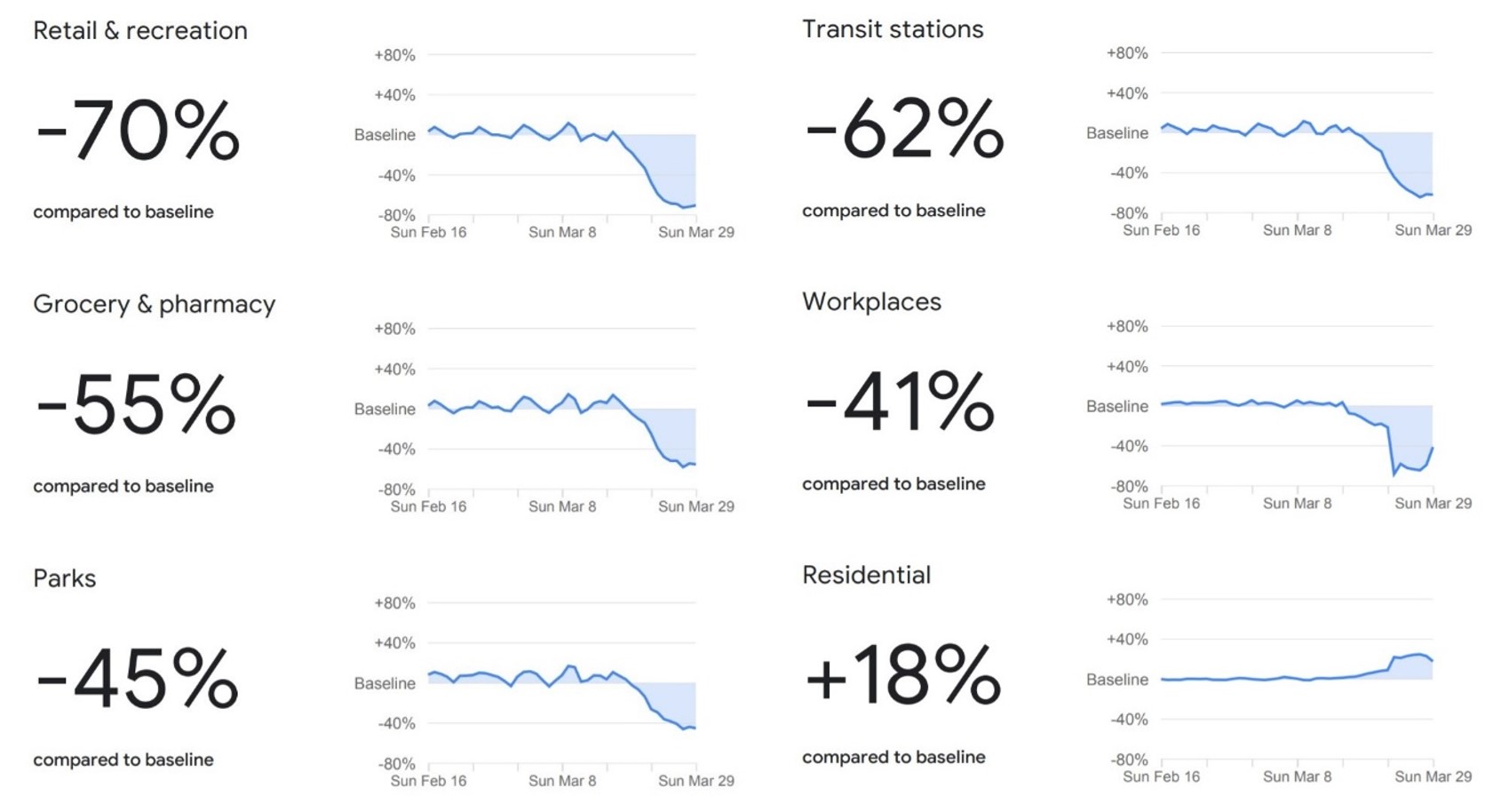
The Google COVID-19 Community Mobility Reports come in and effort to help health workers and law enforcement agencies better understand their communities’ movements. “Each Community Mobility Report is broken down by location and displays the change in visits to places like grocery stores and parks,” Google says in their post. Each report shows six graphs and a corresponding percentage in the negative or positive direction.
The data above comes from the COVID-19 Community Mobility report of Pakistan. The graphs above start off with first showing the normal trend, outside of the lockdown conditions. The dip seen in all graphs except of the last one shows how Mobility activity at each of these locations has decreased, starting on the 15th of March (approximately). Retail and Recreational places have seen a 70% decrease, Grocery stores and Pharmacies, a 55% decrease, Parks, a 45% decrease, Transit stations, a 62% decrease, and Workplaces have seen an overall decrease of 41% in human activity. The sixth graph, the only one seen to have an upward spike, represents the mobility activity seen in residential areas of Pakistan. The graph shows an 18% increase in activity in residential areas.
All of this data shows us that almost all outdoor activities in Pakistan has seen a significant decrease since the middle of March. This is, however, data collected by Google’s location services. Areas where these services are not available, the rural areas of Pakistan, have not been represented in these graphs therefore, the actual data may slightly or significantly vary, depending on how many such areas exist.
Capable of conversing in both Chinese and English, Tencent’s large language model ‘Hunyuan’ is claimed…
Working on multiple AI models, Apple has allocated several teams who are working on artificial…
The world's largest offshore wind turbine has achieved a milestone by setting a new record…
YouTube is stepping into the world of gaming. YouTube has started testing out its gaming…
In a remarkable academic achievement, Abdullah Zaman, a Pakistani student hailing from Attock, has clinched…
Flying Bum, the world's largest aircraft is ready to launch in 2026. The Airlander 10…
Leave a Comment